Navigation and Sailing Instruments
When we were in Cape Town we decided to upgrade our old instruments with a new Maretron system that uses the NMEA 2000 protocol. It’s pretty awesome and has worked great for us in some pretty serious conditions. Not only does it give us normal stuff like wind, depth, and speed but it also has a full weather station built into the wind instruments that gives us barometric pressure, temperature, and humidity. Normally we would have to have a separate weather station (click here to see some examples) which isn’t an issue, but having things combined in one instrument saves space on the boat. Plus, the multi function displays can be configured to show all this data over time which shows you trends graphically as your conditions change. Too cool!
When we were in Cape Town we decided to upgrade our old instruments with a new Maretron system that uses the NMEA 2000 protocol. It’s pretty awesome and has worked great for us in some pretty serious conditions. Not only does it give us normal stuff like wind, depth, and speed but it also has a full weather station built into the wind instruments that gives us barometric pressure, temperature, and humidity. Normally we would have to have a separate weather station (click here to see some examples) which isn’t an issue, but having things combined in one instrument saves space on the boat. Plus, the multi function displays can be configured to show all this data over time which shows you trends graphically as your conditions change. Too cool!
Software and Apps
We ditched our navigation laptop in favor of tablets, which we’ve used extensively for the last 12,000 miles or so. So far all is working awesome and we have a completely wireless system including all instrument data, routing, charting, and radar! First off we run Coastal Explorer on a Windows 10 tablet. This is our primary navigation and charting software when sailing offshore. We have been thinking about upgrading the tablet to a laptop that is able to do more functions and has more storage space. We will need to find a windows 10 activation key online but that would be easy enough. We would still use the Coastal Explorer software though. It is easy, simple, and just works. One of the main attractions is it also works with TCP/IP Based radar , which allows us to view radar embedded on the charts on any PC. Since all the sailing instrument, GPS, and Radar data is broadcast over Wi-Fi this little $150.00 tablet suddenly becomes a hand held, completely portable navigation super computer. You can even do anchor watch from bed 🙂
We ditched our navigation laptop in favor of tablets, which we’ve used extensively for the last 12,000 miles or so. So far all is working awesome and we have a completely wireless system including all instrument data, routing, charting, and radar! First off we run Coastal Explorer on a Windows 10 tablet. This is our primary navigation and charting software when sailing offshore. We have been thinking about upgrading the tablet to a laptop that is able to do more functions and has more storage space. We will need to find a windows 10 activation key online but that would be easy enough. We would still use the Coastal Explorer software though. It is easy, simple, and just works. One of the main attractions is it also works with TCP/IP Based radar , which allows us to view radar embedded on the charts on any PC. Since all the sailing instrument, GPS, and Radar data is broadcast over Wi-Fi this little $150.00 tablet suddenly becomes a hand held, completely portable navigation super computer. You can even do anchor watch from bed 🙂
We also use OpenCPN , which is a free and open source navigation solution for PC’s. We often run OpenCPN and Coastal Explorer side by side. On our iPad we run iNavx with Navionics charts. This is an awesome little program and one of the best for iPads because it gives you AIS data overlayed on the charts. Too cool!
We don’t have to keep many files on our tablet, so we don’t need anything special for that at the moment, although we have been reading about xyplorer recently. It can be downloaded online and sounds very useful for file management and storage.
Lastly we also have the Navionics app for Android installed on a few devices as a backup should anything happen to the other system. Since this uses the GPS sensor on the phone it’s very portable and will work even if something happens to your main system.
Other Equipment
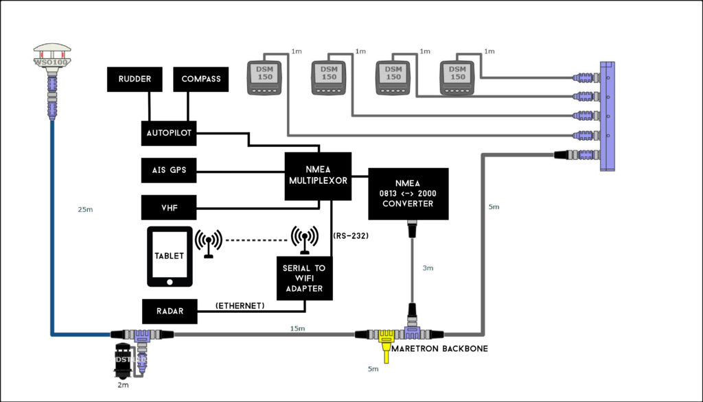
We use the Brookhouse NMEA multiplexer to combine all the data from different systems together. It takes NMEA data from the autopilot, compass, GPS, AIS, and Maretron system and multiplexes it all together into one NMEA stream. We use the Actisense NMEA 0183 <-> 2000 converter to let our new Maretron system talk to the older Raymarine Autopilot, compass, and VHF. All the NMEA data from the navigation and boat systems are broadcast over a RS-232 Wi-FI router, allowing us to see everything on our laptops and tablets! We just grabbed the RS-232 port out of the Brookhouse multiplexor and it send all the data over Wi-Fi that way. Pretty sweet right?!?!?
We use the Brookhouse NMEA multiplexer to combine all the data from different systems together. It takes NMEA data from the autopilot, compass, GPS, AIS, and Maretron system and multiplexes it all together into one NMEA stream. We use the Actisense NMEA 0183 <-> 2000 converter to let our new Maretron system talk to the older Raymarine Autopilot, compass, and VHF. All the NMEA data from the navigation and boat systems are broadcast over a RS-232 Wi-FI router, allowing us to see everything on our laptops and tablets! We just grabbed the RS-232 port out of the Brookhouse multiplexor and it send all the data over Wi-Fi that way. Pretty sweet right?!?!?
System Schematic